

Today’s post comes from Sanjay Kumar, founder of DeterministicAI.tech, a deep-tech research organization developing technologies that make AI systems more predictable, transparent and trustworthy.
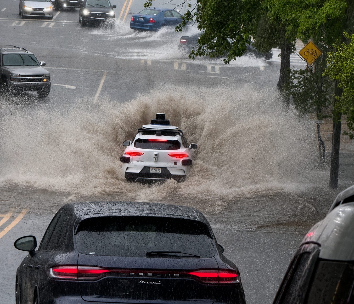
Imagine you are cruising down an Atlanta thoroughfare in the middle of a sudden, blinding downpour. The rain is drumming on your windshield, and up ahead, the asphalt vanishes beneath a deep, murky pool of rushing water.
As a human driver, your brain instantly fires off basic survival instincts: “Turn around, don’t drown.” You scan the surrounding environment, measuring how high the water is rising against the curbs, watching the cars ahead of you, and feeling the sheer force of the storm. You press the brakes.
Now consider the Waymo robotaxi pictured above. Backed by millions of miles of autonomous training data, a suite of custom-engineered microchips, and a physical array of cutting-edge sensors, the vehicle approaches the exact same hazard - and drives straight in.
This dramatic scene isn’t a one-off stunt. It is a real-world snapshot of a fascinating, high-stakes edge case in autonomous vehicle (AV) perception. Following a series of incidents - including a vehicle being swept off a roadway into Salado Creek in San Antonio and cars getting stranded mid-flood in Austin - Waymo officially issued a voluntary recall with NHTSA (National Highway Traffic Safety Administration) covering 3,791 of its driverless vehicles.
How does a multimillion-dollar supercomputer on wheels fail a test that a teenager with a fresh driver’s license could pass? Let’s explore the autonomous systems engineering behind why this happens - and how the industry plans to fix it.
1. Physics vs. LiDAR: Water Acts Like a Mirror
To understand why a self-driving car struggles in a deluge, we have to look at how it sees the road. Waymo’s vehicles rely on sensor fusion, combining cameras, radar and LiDAR (Light Detection and Ranging).
LiDAR is the crown jewel of AV tech. It fires millions of invisible infrared laser pulses every second, measuring how long they take to bounce back to construct a highly detailed 3D point cloud of the vehicle’s surroundings. But fluid physics has a way of breaking lasers:
Specular Reflection (The Mirror Effect): When a laser hits dry, rough asphalt, the light scatters in all directions, sending a strong return signal back to the car's sensors. However, when water covers the road, it acts like a mirror. The laser hits the flat surface of the water and reflects away from the car.
The "Disappearing" Road: Because laser light never bounces back, LiDAR receives zero return data. To the car's perception stack, a deep body of water can register as a flat, empty, clear road. If the car's high-definition (HD) maps say a road should be there, and the sensors detect no obstacles, the computer assumes the path is clear.
2. The Depth Blind Spot
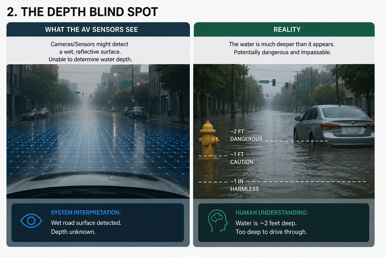
Even if the vehicle’s onboard cameras detect a change in road texture or notice a glossy surface, current computer vision models cannot inherently calculate water depth.
Distinguishing between a harmless one-inch puddle and a catastrophic two-foot torrent requires contextual reasoning. Humans naturally look for physical reference points - how high the water is on a nearby fire hydrant, whether the tires of the car ahead are submerged, or how fast the current is moving. Current vision stacks struggle to compute these abstract, real-time comparisons.
3. The False Positive Dilemma
Every autonomous vehicle programmer must solve a delicate equation: balancing safety with traffic flow.
If a robotaxi executed an emergency stop, swerved, or triggered its hazards every time it encountered a shiny patch of road, a minor puddle, or a wet metallic construction plate, it would cause a nightmare of constant “phantom braking.”
In high-traffic environments, phantom braking is incredibly dangerous, frequently causing human-driven vehicles behind the AV to rear-end it. To keep the ride smooth and predictable, the software is tuned to tolerate minor surface anomalies - which means deep water sometimes gets incorrectly bucketed as an ignorable puddle.
4. The Logic Gap: "Decelerate and Proceed"
The physics of water is only half the story. The trigger for Waymo’s voluntary recall was a specific software logic error.
According to the NHTSA filings, Waymo’s system was designed with a specific instruction for higher-speed roadways (like 40+ mph highways). When the vehicle did detect an untraversable, flooded lane, its programming prioritized keeping traffic moving safely rather than locking up the brakes in the middle of a highway.
The system’s compromise? Decelerate, and attempt to proceed through the water anyway.
This exact logic is what caused an unoccupied Waymo to slow down and then slowly, methodically crawl directly into a high-water area in San Antonio - leading to it being swept away.
The Operational Workarounds - and Why They're Not Enough
While Waymo was quick to respond to the issue, it has not yet solved the fundamental physics problem of water. Instead, the company deployed a combination of operational workarounds and interim measures.
The Final Remedy Is Still Under Development
According to official NHTSA safety recall reports, Waymo's final remedy to resolve how its 5th- and 6th-generation automated driving systems (ADS) handle flooded lanes is still in active development. Because teaching an AI to instantly measure the physical depth of mud-opaque water in real-time is an incredibly complex engineering challenge, there is no set release date for a permanent sensor-based patch.
The Current Workaround
To keep cars out of deep water in the meantime, Waymo implemented an interim remedy:
Dynamic Map Bans: Waymo has updated its high-definition maps to completely block off areas known to be prone to flash flooding.
Weather-Alert Geofencing: The fleet's dispatch system is tied to local National Weather Service (NWS) alerts. If a severe storm or flood warning is issued, robotaxis are restricted from operating in those zones.
The catch: this approach is only as fast as the weather reports. If a sudden cloudburst floods a street before the NWS can issue an official flash flood warning, the geofence won't trigger - leaving the vehicle entirely dependent on its onboard sensors, which, as we've seen, are blind to standing water.
Service Pauses and Current Operations
Following these flood incidents, Waymo has had to temporarily pause services in affected cities during severe weather threats. Yet, despite these weather vulnerabilities, Waymo continues to scale up its operations aggressively, choosing to manage flood risk through strict operational shutdowns rather than a vehicle-level sensory fix.
How Engineers Plan to Fix the "Drowning Robotaxi"
To truly make autonomous vehicles flood-proof, engineers are targeting the physical and computational roots of the problem with three emerging technologies:
1. High-Resolution LiDAR-Like Radar
While LiDAR’s infrared lasers are physically blocked or reflected away by water, millimeter-wave radar can easily penetrate rain, fog and water surfaces.
Researchers are developing systems using multiple, widely spaced radar sensors on the vehicle’s front end. By overlapping the fields of view of two or more radar sensors and applying noise-filtering algorithms, the vehicle can generate a highly detailed 3D imaging point cloud - similar to LiDAR - but unaffected by wet road surfaces. This allows the car to effectively see through the water’s surface to scan the structural roadbed beneath.
2. Relative Contextual Vision (Landmark Comparison)
Since cameras cannot directly measure depth like a ruler, software engineers are training neural networks to infer water depth indirectly using the surrounding environment - a technique called Visual Depth Inference via HD Map Anchors.
The vehicle compares its real-time camera feeds against its highly detailed, pre-loaded dry HD maps. If the camera detects water and notices that a physical landmark - like a curb, a fire hydrant, or a traffic sign - is partially submerged compared to its dry baseline map coordinates, the algorithm can calculate the exact height of the floodwater based on how much of the reference object has disappeared beneath the surface.
3. In-Sensor Edge Computing
Currently, self-driving cars stream massive amounts of sensor data from cameras, LiDAR and radar to their onboard computing platform. However, standard LiDAR pulses bounce off wet surfaces like a mirror, as mentioned, returning empty signals that the car’s software incorrectly interprets as a completely clear, dry road.
To solve this visual blind spot, scientists are developing smart optoelectronic sensors using advanced materials, such as rhenium disulfide. These sensors detect the polarization, the specific angle, of reflected light rather than just brightness, allowing them to physically distinguish between dry asphalt and standing water with over 95% accuracy. By analyzing light behavior directly at the hardware layer via in-sensor computing, the device can flag a flooded surface to the central processor before the vehicle enters a danger area.
The "Matrix" Solution: Waymo Is Simulating the Flood
If you can’t safely teach a physical robotaxi to navigate a flood in the real world without drowning it, how do you fix its brain? You build a virtual world and flood it.
In early 2026, Waymo and Google DeepMind unveiled the Waymo World Model (WWM), built upon DeepMind’s ultra-advanced Genie 3 generative AI engine. WWM acts as a generative simulator for self-driving cars. Rather than relying on simple pre-programmed track scenarios, this model can ingest ordinary 2D video footage - such as a passenger’s phone video or dashcam footage of a flooded street - and convert it into a fully interactive, multimodal 3D simulation.
The key breakthroughs of this simulated training ground include:
Multi-Modal Realism: The model doesn't just generate realistic camera images; it simultaneously synthesizes physically correct LiDAR point clouds. This allows the virtual Waymo Driver to learn exactly how laser light reflects off water surfaces.
Controlling the Uncontrollable: Engineers can use language prompts to instantly manipulate the layout, control traffic, or summon extreme weather events - including massive flash floods, heavy snowstorms, or even tornadoes.
Zero-Risk "What-If" Training: Waymo uses this system to safely run thousands of "counterfactual" scenarios. They can ask: "What if the driver didn't decelerate on this flooded highway lane?" or "How would the LiDAR react if the water rose by six more inches?" All of this training happens in the safety of a server rack, without risking a single scratch on their real-world vehicles.
Building an AI that can handle 99% of predictable, dry-weather driving is incredibly difficult. But solving for the fluid, unpredictable physics of the real world - where a road can transform into a river in a matter of minutes - is the true engineering frontier.
-Sanjay
Maybe they do it for fun